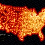
Data Visualization of the Day: The contiguous United States, visualized by distance to the nearest McDonald’s.
Stephen Von Worley @ Weather Sealed compiled this rather spectacular infographic using a list of all 13,000+ US locations of McDonald’s (the “barometer of cookie-cutter commercialism creep”) in order to determine where true wilderness lies within the lower 48.
The result?
Between the tiny Dakotan hamlets of Meadow and Glad Valley lies the McFarthest Spot: 107 miles distant from the nearest McDonald’s, as the crow flies, and 145 miles by car!
Golden arches being erected near the tiny Dakotan hamlets of Meadow and Glad Valley in 3… 2…
[via.]